Ordnance Survey
| Ordnance Survey | |
|---|---|
| Formation | 1791[1] |
| Type | Executive agency of the United Kingdom government |
| Purpose/focus | The national mapping agency for Great Britain |
| Headquarters | Romsey Road, Southampton, SO16 4GU |
| Region served | Great Britain and, to an extent, the Isle of Man)[2] |
| Website | www.ordnancesurvey.co.uk |

Ordnance Survey is an executive agency and non-ministerial department of the United Kingdom government.[3] It is the national mapping agency for Great Britain,[2] and one of the world's largest producers of maps. The name reflects the original military purpose of the organisation (see ordnance and surveying) in mapping Britain during the Napoleonic Wars when there was a threat of invasion from France, and its logo includes the War Department's broad arrow heraldic mark. Ordnance Survey mapping is usually classified as 'large scale' (i.e. showing more detail) or 'small scale'. Large-scale mapping comprises maps at six inches to the mile or more (1:10,560, superseded by 1:10,000 in the 1950s); it was available in sheet-map form till the 1980s, since when it has become digital. Small-scale mapping comprises maps at fewer than six inches to the mile and includes the "leisure maps", such as the popular one inch to the mile and its metric successors, still available in traditional sheet-map form. Ordnance Survey of Great Britain maps are in copyright for 50 years after publication date. Some of the Copyright Libraries hold complete or near-complete collections of pre-digital O.S. mapping.
Contents |
Origins
The roots of Ordnance Survey go back to 1747, when Lieutenant-Colonel David Watson proposed the compilation of a map of the Scottish Highlands to facilitate the subjection of the clans following the Jacobite rising of 1745.[4] In response, King George II commissioned a military survey of the Highlands, and Watson was placed in charge under the command of the Duke of Cumberland. Among his assistants were William Roy, Paul Sandby, and John Manson. The survey was produced at a scale of 1 inch to 1000 yards.[5] The labours of Watson and Roy, in particular, resulted in The Duke of Cumberland's Map, now in the British Library. Roy would go on to have an illustrious career in the Royal Engineers, and he was largely responsible for the British share of the work in determining the relative positions of the French and British royal observatories. This work was the starting point of the Principal Triangulation of Great Britain (1783 – 1853), and led to the creation of the Ordnance Survey itself. Roy's technical skills and leadership set the high standard for which Ordnance Survey became known. Work was begun in earnest in 1790 under Roy's supervision, when the Board of Ordnance (a predecessor of part of the modern Ministry of Defence) began a national military survey starting with the south coast of England.
By 1791, the Board received the newer Ramsden theodolite (an improved successor to the one that Roy had used in 1784), and work began on mapping southern Great Britain using a baseline that Roy himself had previously measured and that crosses the present Heathrow Airport. A set of postage stamps, featuring maps of the Kentish village of Hamstreet, was issued in 1991 to mark the bicentenary.
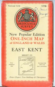
In 1801, the first one-inch-to-the-mile (1:63,360 scale) map was published, detailing the county of Kent, with Essex following shortly after. The Kent map was published privately and stopped at the county border while the Essex maps were published by Ordnance Survey and ignore the county border, setting the trend for future Ordnance Survey maps.[6]
During the next twenty years, roughly a third of England and Wales was mapped at the same scale (see Principal Triangulation of Great Britain). It was gruelling work: Major Thomas Colby, later the longest serving Director General of Ordnance Survey, walked 586 miles (943 km) in 22 days on a reconnaissance in 1819. In 1824, Colby and most of his staff moved to Ireland to work on a six-inches-to-the-mile (1:10,560) valuation survey. The survey of Ireland, county by county, was completed in 1846.[5] The suspicions and tensions it caused in rural Ireland are the subject of Brian Friel's play Translations.
Colby was not only involved in the design of specialist measuring equipment. He also established a systematic collection of place names, and reorganised the map-making process to produce clear, accurate plans. He believed in leading from the front, travelling with his men, helping to build camps and, as each survey session drew to a close, arranging mountain-top parties with enormous plum puddings.[7]

The Great Britain 'County Series'
After the first Ireland maps came out in the mid-1830s, the Tithe Commutation Act 1836 led to calls for a similar six-inch to the mile survey in England and Wales. Official procrastination followed, but the development of the railways added to pressure that resulted in the 1841 Ordnance Survey Act. This granted a right to enter property for the purpose of the survey. Following a fire at its headquarters at the Tower of London in 1841,[8] Ordnance Survey was in disarray for several years, with arguments about which scales to use. Major-General Sir Henry James was by then Director General, and he saw how photography could be used to make maps of various scales cheaply and easily. He developed and exploited photozincography not only to reduce the costs of map production but also to publish 'facsimiles' of nationally important manuscripts. Between 1861 and 1864, a 'facsimile' of the Domesday Book was issued, county by county.
After the fire, Ordnance Survey relocated to a site in Southampton and from the 1840s concentrated on the Great Britain 'County Series', modelled on the earlier Ireland survey. A start was made on mapping the whole country at six inches to the mile (1:10,560). From 1854, to meet requirements for greater detail, including land-parcel numbers and acreages, cultivated and inhabited areas were mapped at 1:2500 (25.344 inches to the mile), at first parish by parish, with blank space beyond the parish boundary, and later continuously.[9] Early copies of the 1:2500s were available hand-coloured. The parish maps were accompanied by "area books" that gave field and land-parcel acreages and land-use information. After 1854, the six-inch maps and their revisions were based on the "twenty-five inch" maps and theirs. The six-inch sheets covered an area of six by four miles on the ground; the "twenty-five inch" sheets an area of one by one and a half. In later editions the six-inch sheets were published in "quarters" (NW,NE,SW,SE), each covering an area of three by two miles on the ground. The first edition of the two scales was completed by the 1890s. A second edition (or "first revision") was begun in 1891 and completed just before the First World War. From 1907 till the early 1940s, a third edition (or "second revision") was begun but never completed: only areas with significant changes on the ground were revised, many two or three times.[10] [11]
Meanwhile funding had been agreed in the 1850s for a more detailed survey of towns and cities. From 1850-53, twenty-nine towns were mapped at 1:528 (10 feet to the mile). From 1855 10.56 feet to the mile (1:500) became the preferred scale. London and some seventy other towns (mainly in the north) were already being mapped at 1:1056 (5 feet to the mile). Just under 400 towns with a population of over 4000 were surveyed at one of these three scales, most at 1:500. Publication of the town plans was completed by 1895. The London first edition was completed and published in 326 sheets in the 1860s-70s; a second edition of 759 sheets was completed and brought out in the early 1890s; further revisions (incomplete coverage of London) followed between 1906 and 1937. Very few other towns and cities saw a second edition of the town plans.[12] [6]
From 1911 onwards (mainly 1911-1913), the Ordnance Survey photo-enlarged to 1:1250 (50.688 inches to the mile, or "fifty-inch") many 1:2500 sheets covering built-up areas, for Land Valuation / Inland Revenue purposes. About a quarter of these 1:1250s were marked "Partially revised 1912/13". In areas where there were no further 1:2500s, these partially revised "fifty inch" sheets represent the last large-scale revision (larger than six-inch) of the County Series. The County Series mapping was superseded by the National Grid 1:1250s, 1:2500s and 1:10,560s after the Second World War.[13]
From the late 19th century to the early 1940s, for War Office purposes, the O.S. produced some "restricted" versions of the County Series maps at 1:2500 and six inch, that included details of military significance, such as dockyards, naval installations, fortifications, and military camps. These areas were left blank or incomplete on standard maps - though for a brief period in the early 1930s, during the Disarmament talks, some of the blanks were filled in. The War Department 1:2500s, unlike the standard issue, were contoured. The de-classified sheets have now been deposited in some of the Copyright Libraries, helping to complete the map-picture of pre-Second World War Britain.
The 20th century

During the First World War, Ordnance Survey was involved in preparing maps of France and Belgium for its own use, and many more maps were created during World War II, including:
- 1:40000 scale map of Antwerp, Belgium
- 1:100000 scale map of Brussels, Belgium
- 1:5000000 scale map of South Africa
- 1:250000 scale map of Italy
- 1:50000 scale map of Northeast France
- 1:30000 scale map of the Netherlands with manuscript outline of German Army occupation districts.
After the war, Colonel Charles Close, then Director General, developed a marketing strategy using covers designed by Ellis Martin to increase sales in the leisure market. In 1920 O. G. S. Crawford was appointed Archaeology Officer and played a prominent role in developing the use of aerial photography to deepen understanding of archaeology.
In 1935, the Davidson Committee was established to review Ordnance Survey's future. The new Director General, Major-General Malcolm MacLeod, started the retriangulation of Great Britain, an immense task involving erecting concrete triangulation pillars (trig points) on prominent (often inaccessible) hilltops throughout Great Britain. These were intended to be infallibly constant positions for the theodolites during the many angle measurements, which were each repeated no less than 32 times.
The Davidson Committee's final report set Ordnance Survey on course for the twentieth century. The national grid reference system was launched, with the metre as its unit of measurement. An experimental 1:25000 scale map was introduced. The one-inch maps remained for almost forty years before being superseded by the 1:50000 scale series, as proposed by William Roy more than two centuries earlier.
Ordnance Survey had outgrown its site in the centre of Southampton (made worse by the bomb damage of the Second World War). The bombing during the Blitz devastated Southampton in November 1940 and destroyed most of Ordnance Survey's city centre offices. Staff were dispersed to other buildings, and to temporary accommodation at Chessington and Esher, Surrey, where they produced 25000 scale maps of France, Italy, Germany and most of the rest of Europe in preparation for the invasion of Europe. The OS largely remained at Chessington until 1969 when a new purpose-built headquarters was opened in the Southampton suburb of Maybush. Some of the remaining buildings of the original Southampton city-centre site are now used as part of the court complex.
In 1995, Ordnance Survey digitised the last of about 230,000 maps, making the United Kingdom the first country in the world to complete a programme of large-scale electronic mapping. In 1999 Ordnance Survey was designated a Trading Fund, required to cover its costs by charging for its products and remit a proportion of its profits to the Treasury. Officially, it is now a civilian organisation with executive agency status.
In April 2009 construction began on a new head office located at Adanac Park on the outskirts of Southampton[14].
GB map range
Ordnance Survey produces a large variety of paper maps and digital mapping products.
Leisure maps
OS's range of leisure maps are published in a variety of scales:
- Tour (c.1:100,000 scale except Scotland) – One-sheet maps covering a generally county-sized area, showing major and most minor roads and containing tourist information and selected footpaths. Tour maps are generally produced from enlargements of 1:250,000 mapping. Several larger scale town maps are provided on each sheet for major settlement centres. The Tour maps have sky-blue covers and there are now eight sheets in the series.
- OS Landranger map (1:50,000 scale) – The "general purpose" map. They have pink covers; 204 sheets cover the whole of Great Britain and the Isle of Man. The map shows all footpaths and the format is similar to that of Explorer, albeit with less detail.
- OS Landranger Active map (1:50,000 scale) – select OS Landranger maps are available in a plastic-laminated waterproof version, similar to the OS Explorer Active range. As of October 2009[update], 25 of the 204 Landranger maps were available as OS Landranger Active maps.
- OS Explorer map and Outdoor Leisure (1:25,000 scale) – Specifically designed for walkers and cyclists. They have orange covers, and the two series together contain 403 sheets covering the whole of Great Britain (the Isle of Man is excluded from this series). These are the most detailed leisure maps that Ordnance Survey publish and cover all types of footpaths and most details of the countryside for easy navigation. The Outdoor Leisure series complement the OS Explorer Map, showing areas of greater interest in England and Wales (e.g. Lake District, Black Mountains) with an enlarged area coverage. It appears identical to the Explorer, except the numbering and a little yellow mark on the corner (relic of the old OL series). The OS Explorer maps, together with Outdoor Leisure, superseded the previous Pathfinder maps (green covers) which were numerous in their coverage of the country.
- OS Explorer Active map (1:25,000 scale) – the OS Explorer and Outdoor Leisure maps are also available in a plastic-laminated waterproof version.
Until recently OS also produced the following:
- Route (1:625,000 scale) – A double-sided map designed for long-distance road users, covering the whole of Great Britain.
- Road (1:250,000 scale) – A series of eight sheets covering Great Britain, designed for road users.
These, along with fifteen Tour maps, were discontinued during January 2010 as part of a drive for cost-efficiency, Ordnance Survey believing these products could no longer compete with similar maps produced by other companies and satellite navigation devices.
Custom products
Ordnance Survey also offers a print-on-demand service called 'OS Select'. This is printed to order from digital raster data, allowing the customer to choose exactly which area the map should cover. There is choice of two scales: 1:50,000 (area covered 40 km x 40 km) or 1:25,000 (area covered 20 km x 20 km).
Ordnance Survey also produces more detailed custom mapping at 1:10,000 (Landplan) and 1:1,250 or 1:500 (Siteplan), which is available from some of the more specialist outlets. Again, this is produced to order from Ordnance Survey large-scale digital data, and custom scales can also be produced by enlargement or reduction of existing scales.
In addition, Ordnance Survey also produces maps for educational use, which are faithful reproductions of old Ordnance Survey maps dating from the early 1970s to the early 1990s (estimated). These maps are widely seen in British schools and schools in former British colonies (including the Commonwealth), either as stand-alone geographic aids or sold as part of geography workbooks and/or textbooks.
Derivative and licensed products
One series of historic maps[15] is a reprint of the Ordnance Survey first series from the mid 19th century, but re-scaled to 1:50,000, re-projected to the OS Landranger map projection, and given 1 km gridlines. This means that features from over 150 years ago fit almost exactly over their modern equivalents, and modern grid references can be given to old features.
The digitisation of the data has allowed Ordnance Survey to experiment with selling maps electronically. Several companies are now licensed to produce the popular scales (1:50,000 and 1:25,000) of map on CD/DVD or to make them available online for download. The buyer typically has the right to view the maps on a PC, a laptop and a pocket PC/smartphone, and to print off any number of copies. The accompanying software is GPS-aware, and the maps are ready-calibrated. Thus, the user can quickly transfer a desired area from their PC to their laptop or smartphone, and go for a drive or walk with their position continually pinpointed on the screen. The price for an individual map is more expensive than the equivalent paper version, but the price per square km falls rapidly with the size of coverage bought.
Cartography
The original maps were made by triangulation. For the second survey, in 1934, this process was used again, and resulted in the building of many triangulation pillars (trig points): short (approx 4 feet/1.2 m high), usually square, concrete or stone pillars at prominent locations such as hill tops. Their precise locations were determined by triangulation, and the details in between were then filled in with less precise methods. Modern Ordnance Survey maps are based on aerial photographs, but large numbers of the pillars remain, many of them adopted by private land owners.
Ordnance Survey still maintains a set of master geodetic reference points to tie the Ordnance Survey geographic datums to modern measurement systems including GPS. Ordnance Survey maps of Great Britain do not use latitude and longitude to indicate position but a special grid. The grid is technically known as OSGB36 (Ordnance Survey Great Britain 1936), and was introduced after the retriangulation of 1936–53.
OS MasterMap
Ordnance Survey's flagship digital product, launched in November 2001, is OS MasterMap. This is a database that records every fixed feature of Great Britain larger than a few metres in one continuous digital map. Every feature is given a unique TOID (TOpographical IDentifier), a simple identifier that includes no semantic information. Typically each TOID is associated with a polygon that represents the area on the ground that the feature covers, in National Grid coordinates. OS MasterMap is offered in themed "layers", for example, a road layer and a building layer, each linked to a number of TOIDs. Pricing of licenses to OS MasterMap data depends on the total area requested, the layers licensed, the number of TOIDs in the layers, and the period in years of the data usage.
OS MasterMap can be used to generate maps for a vast array of purposes, and maps can be printed from OS MasterMap data with detail equivalent to a traditional 1:1250 paper map.
Ordnance Survey claims that OS MasterMap data is never more than six months out of date, thanks to continuous review. The scale and detail of this mapping project is unique. Around 440 million TOIDs have so far been assigned, and the database stands at 600 gigabytes in size. As of 2005, OS MasterMap was at version 6.
Ordnance Survey is encouraging users of its old OS Landline data to migrate to OS MasterMap and in June 2007 announced a notice of withdrawal for this product as of 30 September 2008.[16]
Geographical information science research
For several decades, Ordnance Survey has had a Research department that is very active in several areas of geographical information science, including:
- Spatial cognition
- Map Generalisation
- Spatial Data Modelling
- Remote sensing and analysis of remotely sensed data
- Semantics and ontologies
Ordnance Survey actively supports the academic research community through its External Research and University Liaison team. The Research department actively supports MSc and PhD students as well as engaging in collaborative research. Most Ordnance Survey products are available to UK universities that have signed up to the Digimap agreement and data is also made available for research purposes that advances Ordnance Survey's own research agenda.
More information can be found at Ordnance Survey Research.
Access to data and criticisms
Ordnance Survey has been subject to criticisms. Most criticism centres on the point that Ordnance Survey possesses a virtual government monopoly on geographic data in the UK,[17] while, although a government agency, since 1999 it has been required to act as a Trading Fund or commercial entity. This means that it is supposed to be totally self-funding from the commercial sale of its data and derived products - whilst at the same time it is supposed to be the public supplier of geographical information. In 1985 the "Committee of Enquiry into the Handling of Geographic Information" was set up in to “advise the Secretary of State for the Environment within two years on the future handling of geographic information in the UK, taking account of modern developments in information technology and market needs”. The Committee's final report was published under the name of its chairman, Roger Chorley, in 1987.[18] The report stressed the importance of widely available geographic information to the UK and recommended a loosening of government policies on distribution and cost recovery.
In March 2006 The Guardian newspaper's Technology section began a "Free Our Data" campaign, calling for the raw data gathered by Ordnance Survey (not to mention data gathered on its behalf by local authorities at public expense) to be made freely available for reuse by individuals and companies, as happens, for example, with such data in the USA. However, Ordnance Survey claims that the quality of the freely available government mapping in the USA is low or variable because of funding issues.[19]
On the 7 April 2006 the Office of Public Sector Information (OPSI) received a complaint from the data management company Intelligent Addressing.[20] Many, although not all, complaints were upheld by the OPSI, one of the conclusions being that Ordnance Survey "is offering licence terms which unnecessarily restrict competition". Negotiations between Ordnance Survey and interested parties are ongoing with regard to the issues raised by the OPSI report, Ordnance Survey being under no obligation to comply with the report's recommendations.
Since August 2007, Ordnance Survey has contracted the political lobbying company Mandate Communications[21] to help campaign against the free data movement and discover which politicians and advisers continue to support their current policies.[22]
In November 2009 the Prime Minister announced that "mid-scale" data from Ordnance Survey would be made available for free reuse, including commercial applications[23], from April 2010. A consultation was held inviting responses between 23 December and 17 March by the Department of Communities and Local Government.
OS OpenData
In response to the feedback from the consultation, the government announced [24] that a package of Ordnance Survey data sets would be released for free use and re-use. On 1 April 2010 Ordnance Survey released[25] the brand OS OpenData, under an attribution-only license compatible with CC-by[26]. Various groups and individuals had campaigned for this release of data, but some were disappointed when the some of the profitable datasets were not included - withheld for the counter-argument that if licensees don't pay for OS data collection then the government would have to be willing to foot a £30m p.a. bill, to obtain the future economic benefit of sharing the highly detailed mapping produced by the UK's national agency.[27].
The files have been cached on the MySociety website for convenient download.[28]
Files include:
OS StreetView
Street-level map emphasising roads and their names and major buildings.
Meridian 2
Vector data of various 'themes'. Communication theme: roads and railways, boundaries, and coastline. Topographic theme: boundaries and coastline, developed land-use areas, cartographic names, hydrology, and woodlands.
VectorMap District
Mid-scale vector dataset designed to display information on the web (mid-scale customisable mapping)
Boundary Line
Vector data of local government administrative boundaries and electoral boundaries.
1:50 000 Scale Gazetteer
List of locations to 1km resolution, with coordinates and OS grid references. Includes airports, farms, hills, woodlands, commons, and over 42 000 towns and settlements.
MiniScale
Smallest scale data provided. Shows broad landscape features including boundaries, settlements, main communications, and physical features.
Code-Point Open
Provides location for central position of each postcode in Great Britain. Data contains postcodes, easting and northing coordinates, NHS codes, and administrative codes. In CSV format; updated every February, May, August, and November.
Strategi
Vector data to be used with the 1:250 000 Scale Colour Raster data for use at regional level. Layers include roads, railways, airports, ferries, water features, ceremonial boundaries, cities, towns and other settlements, woods and land use, and geographic names.
Land-Form PANORAMA
Vector data for physical ground shape: contours, coastlines, lakes etc.
1:250 000 Scale Colour Raster
Regional map, similar in resolution to a road atlas. Shows cities, towns, villages, motorways, A and B class roads, railways, rivers and some woodlands. With 1:250 000 scale gazetteer of relevant names and a digital legend.
OS Locator
Gazetteer of road names (without geometry of road). Contains coordinates defining a rectangle delimiting the extent of the road referenced.
Historical material
Ordnance Survey historical works are generally available, as the agency is covered by Crown Copyright: works more than fifty years old, including historic surveys of Britain and Ireland and much of the New Popular Edition, are in the public domain. However, finding suitable originals remains an issue as Ordnance Survey does not provide historical mapping on 'free' terms, instead marketing commercially 'enhanced' reproductions in partnership with Landmark. This can be contrasted with, for example, the approach in the Republic of Ireland in more recent times, where Ordnance Survey Ireland claims regular copyright over its mapping (and over digital copies of the public domain historical mapping).
See also
- Alastair Macdonald
- Cartography
- Geoinformatics
- Grid reference
- British national grid reference system
- Irish national grid reference system
- Hydrography
- Hydrographic survey
- United Kingdom Hydrographic Office
- Maps of the UK and Ireland
- Martin Hotine
- National mapping agency
- Ordnance Survey International
- Romer
- Sea level
References
- Margary, Harry (1992). Old Series Ordnance Survey Maps of England and Wales. Unknown. ISBN 0-903541-01-7.
- "Official Homepage". Official Homepage. http://www.ordnancesurvey.co.uk. Retrieved September 29, 2005.
- "History of Cartography". Academic research by the University of Exeter. http://www.ex.ac.uk/geography/research/maphist.html. Retrieved September 29, 2005.
Footnotes
- ↑ "Ordnance Survey". The Oxford Companion to Irish History. Oxford University Press. 2007. http://www.encyclopedia.com/doc/1O245-OrdnanceSurvey.html. Retrieved 2009-09-30.
- ↑ 2.0 2.1 Note that Ordnance Survey deals only with maps of Great Britain (and to an extent, the Isle of Man). Northern Ireland, although part of the United Kingdom, is mapped by a separate government agency, the Ordnance Survey of Northern Ireland.
- ↑ List of ministerial responsibilities (including Executive Agencies and Non-Ministerial Departments)
- ↑ Porter, Whitworth (1889). History of the Corps of Royal Engineers. I. London: Longmans, Green, and Co. pp. 167–68. http://books.google.com/?id=lqlBAAAAIAAJ. Retrieved 2008-08-14
- ↑ 5.0 5.1 Hindle, Paul (1998). Maps for Historians. Phillimore & Co. pp. 114–115. ISBN 0850339340.
- ↑ 6.0 6.1 Hindle, Paul (1998). Maps for Historians. Phillimore & Co. pp. 117. ISBN 0850339340.
- ↑ "A brief history of Ordnance Survey". http://www.ordnancesurvey.co.uk/oswebsite/aboutus/history/index.html. Retrieved 2010-01-09.
- ↑ "Key dates". London Fire Brigade. Archived from the original on 2008-06-18. http://web.archive.org/web/20080618055617/http://www.london-fire.gov.uk/about_us/our_history/key_dates.asp. Retrieved 2010-01-09.
- ↑ Harley, J. B., Ordnance Survey Maps: a descriptive manual, O.S. Southampton, 1975
- ↑ Oliver, Richard, Ordnance Survey Maps: a concise guide for historians (London 2005)
- ↑ Oliver, Richard, and Hellyer, Roger, Ordnance Survey of Great Britain: Indexes to the 1:2500 and six-inch scales, David Archer, Newtown, Montgomeryshire, 2002
- ↑ Oliver, Richard, Ordnance Survey Maps: a concise guide for historians (London 2005)
- ↑ Oliver, Richard, Ordnance Survey Maps: a concise guide for historians (London 2005)
- ↑ Ordnance Survey (2009-04-03). "Ordnance Survey breaks ground at Adanac Park". Press release. http://www.ordnancesurvey.co.uk/oswebsite/media/news/2009/april/groundbreaking.html. Retrieved 2009-12-07.
- ↑ Published by Cassini Publishing Ltd. (OS Licensed Partner)
- ↑ Land-Line: detailed large-scale digital map of Great Britain in 229,000 tiles from Ordnance Survey
- ↑ Guardian
- ↑ Chorley, R.R.E. (1987) Handling Geographic Information. Report of the Committee of Enquiry chaired by Lord Chorley, London: HMSO.
- ↑ "Free Our Data: Articles: the Ordnance Survey official response". The Guardian. http://www.freeourdata.org.uk/ordnancereply.php. Retrieved 2008-08-20.
- ↑ OPSI
- ↑ Greg Clark Written Questions, 1 May 2008 col. 668W Ordnance Survey: Mandate Communications
- ↑ Cross, Michael (21 August 2008). "Ordnance Survey hires PR company to lobby politicians". The Guardian. http://www.guardian.co.uk/technology/2008/aug/21/politicsandtechnology.
- ↑ "Ordnance Survey to open up data - PM". 17 November 2009.
- ↑ "Policy options for geographic information from Ordnance Survey: Consultation - Government Response". Department for Communities and Local Government. http://www.communities.gov.uk/publications/corporate/ordnancesurveyconresponse. Retrieved 2010-04-05.
- ↑ "Ordnance Survey launches OS OpenData in groundbreaking national initiative". Ordnance Survey. 2010-04-01. http://www.ordnancesurvey.co.uk/oswebsite/media/news/2010/April/OpenData.html. Retrieved 2010-04-16.
- ↑ "OpenData License Terms and Conditions" (pdf). Ordnance Survey. http://www.ordnancesurvey.co.uk/oswebsite/opendata/licence/docs/licence.pdf. Retrieved 2010-04-05.
- ↑ "The Ordnance Survey has opened up its map data for free after a long campaign. Find out what was released". The Guardian. 2010-04-02. http://www.guardian.co.uk/news/datablog/2010/apr/02/ordnance-survey-open-data. Retrieved 2010-04-16.
- ↑ "OS OpenData downloads". mySociety. http://parlvid.mysociety.org:81/os/. Retrieved 2010-04-05.
External links
- Ordnance Survey
- Aerial view
- 19th century Ordnance Survey maps of Lancashire
- National GPS network information: A guide to coordinate systems in Great Britain
- The Guardian: Devil is in the detail as OS maps out the future by Paul Brown, 8 March 2004
- Royal Engineers Museum - Survey - origins of the Ordnance Survey
- Royal Engineers Museum - General Roy - Biography
- FieldenMaps.info - information on the history of Ordnance Survey maps
- Scans of the OS Popular Edition - England and Wales (1920-30s)
- Scans of the OS New Popular Edition - England and Wales (1940-50s)
Video clips
|
||||||||||||||
|
||||||||||
.svg.png)